
Taal Volcano Protected Landscape
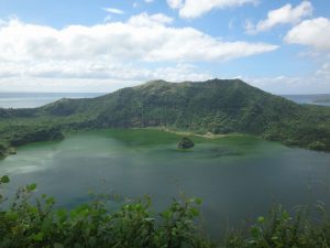
Small but terrible is how most Caviteños and Batanguenos describe Taal volcano. Although relatively small in nature, Taal Volcano is the second most active volcano in the Philippines, Taal Volcano is small yet active; low yet deadly. Nonetheless, its plendor view keeps on luring travelers in and outside of the country. It is also popularly known as “a volcano within a lake, and a lake within a volcano”. The most prominent of which is the Crater Lake, which dominates the central portion of the Volcano Island. Taal Volcano Island is a 23 sq km post-caldera feature and is composed of 47 identified cones and craters. On the island is the 2-km wide and 80-m deep Main Crater Lake. Volcanic processes such as base surges, ashfalls, and effusions of lava led to the formation of this island volcano.
Taal Volcano Protected Landscape (TVPL) has a total area of 62,292.1369 hectares covering the Taal Volcano Island, Taal Lake, and the watershed areas of the surrounding municipalities. TVPL was formerly known as Taal Volcano Island National Park by the virtue of Proclamation No.235 dated July 22, 1967. In 1996, President Fidel V. Ramos declared the island park as a protected area under the category of protected landscape under Proclamation No. 923 consequently bearing its new name. The declaration was made in order to preserve the scenery as well as the animals and plants thriving in the area.